
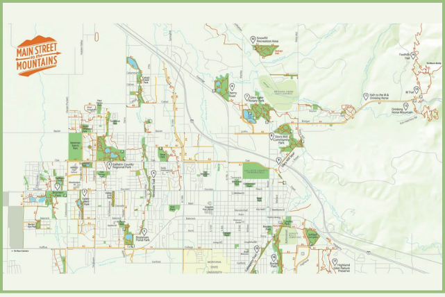
Get the Gallatin Valley Land Trust trail map here.
10 Best Day Hikes Near Bozeman: Distances, Difficulty and Dog Rules
Bozeman has more good day hikes within an hour's drive than most people can get through in a summer. Ten minutes from downtown you can be climbing the M. Forty minutes puts you in Hyalite Canyon with waterfalls every half mile. An hour gets you a summit in the Bridgers or an alpine lake in the Lee Metcalf Wilderness.
This guide covers ten of them, grouped by where they are so you can match the hike to the time you have, plus one in-town hill every local knows. Each entry lists distance, elevation gain, difficulty, best season, dog rules and the drive from downtown. Conditions change fast here. Check the Custer Gallatin National Forest alerts or call the Bozeman Ranger District at 406-522-2520 before driving up, and carry bear spray on every one of these.
Quick Answers
- Closest hike to downtown: the M Trail, 10 minutes away. Closest walk: Peets Hill, which starts a few blocks from Main Street.
- Best for kids and strollers: Palisade Falls, a paved 1.2-mile round trip to an 80-foot waterfall.
- Best summit: Sacagawea Peak, 4 miles round trip to the highest point in the Bridger Range.
- Snow: Hyalite Lake and Sacagawea Peak hold snow into July. Hyalite Canyon Road reopens to cars May 15. The M, Sypes Canyon and Peets Hill are usable year-round with traction in winter.
- Dogs: allowed on every hike on this list. Peets Hill is off-leash; the others are leash or voice control. Details under each entry.
Before You Leave Town: The Bonus Hill
Peets Hill (Burke Park)
- Distance: Up to 3.2 miles of trail; most loops run 1 to 2 miles
- Elevation gain: A couple hundred feet
- Difficulty: Easy to moderate
- Best season: Year-round; icy in winter, muddy in spring
- Dogs: Off-leash unless signed otherwise
- Trailhead: Church Avenue at East Story Street, five minutes from Main Street; a second lot with restrooms at Josephine and Kenyon
Not a hike by Bozeman standards, but it's where locals go when there's an hour of daylight left. A gravel path climbs a ridge above downtown to two overlooks and a mountain range finder that names every peak you'll hike later in this list. Dogs run off-leash, sledders own it in winter, and the sunset view is the best in town. The park exists because the Gallatin Valley Land Trust made it their first community trails project in 1993; we wrote about that work in our post on GVLT's Pay It Trailward campaign.
Close to Town: The Bridger Foothills
The M Trail
- Distance: 1.7 miles round trip (steep route) or about 3 miles (gradual route)
- Elevation gain: 800 feet
- Difficulty: Moderate
- Best season: Year-round; microspikes in winter
- Dogs: Allowed, leash required on the lower trail
- Trailhead: Bridger Canyon Road, 10 minutes from downtown
Bozeman's outdoor stair stepper. Two routes leave the same parking lot: a direct trail that goes straight up the face, and a switchbacked trail that takes its time. Both end at the big white M with the whole Gallatin Valley below you. Locals run it before work. Visitors do it the first morning they're in town. Go at sunrise or after 6 pm in summer to avoid the heat and the crowd.
Sypes Canyon
- Distance: 4 miles round trip to the first overlook; 6.2 miles to the Foothills Trail junction
- Elevation gain: 1,627 feet
- Difficulty: Moderate
- Best season: Year-round; boots with good traction in winter
- Dogs: Allowed
- Trailhead: Sypes Canyon Road off Bridger Canyon Road, 15 minutes from downtown
The quieter alternative to the M. The trail climbs through Douglas fir and open sagebrush to a rocky overlook with the Bridgers behind you and the valley in front, then keeps going to the Bridger Foothills Trail if you want more. Good shoulder-season hike: it melts out early, holds snow late, and gets wildflowers in late spring.
Bear Canyon to New World Gulch
- Distance: About 12 miles round trip
- Elevation gain: About 2,500 feet
- Difficulty: Hard
- Best season: June through October
- Dogs: Allowed
- Trailhead: Bear Canyon exit off I-90, 10 minutes from downtown
The long day close to home. Bear Canyon starts in the foothills just east of town and climbs through forest and open meadow to the ridge, then drops toward New World Gulch and Mystic Lake. It's the hike for a full day when you don't want to drive. Carry water; there's little along the ridge.
Hyalite Canyon: 20 Miles South
Hyalite is Bozeman's backyard range. The canyon road closes to cars April 1 to May 15 each spring and cell service ends at the reservoir, so download your map before you go.
Palisade Falls
- Distance: 1.2 miles round trip
- Elevation gain: About 250 feet
- Difficulty: Easy
- Best season: May through October
- Dogs: Allowed on leash
- Trailhead: Palisade Falls parking area, 40 minutes from downtown
A paved trail to an 80-foot waterfall. Fifteen minutes of walking, stroller and wheelchair accessible, and it delivers. This is the hike for visiting grandparents, kids who are done after a mile, or anyone who wants a waterfall without a workout. It fills up on summer afternoons; go in the morning or in September. We wrote a full guide: Palisade Falls, an accessible trail in Hyalite Canyon.
Grotto Falls
- Distance: 2.5 miles round trip
- Elevation gain: About 280 feet
- Difficulty: Easy
- Best season: June through October
- Dogs: Allowed
- Trailhead: Grotto Falls trailhead at the end of Hyalite Canyon Road, 45 minutes from downtown
A wide, gentle path along Hyalite Creek to a waterfall with a picnic table just before it. The first stretch is accessible dirt. Easy enough for young kids, and it's the start of the longer Hyalite Creek Trail, so you can turn it into a bigger day whenever you want.
Hyalite Creek Trail to Hyalite Lake
- Distance: 11.3 miles round trip
- Elevation gain: About 2,150 feet
- Difficulty: Hard
- Best season: July through early October; snow often lingers into July
- Dogs: Allowed
- Trailhead: Grotto Falls trailhead, 45 minutes from downtown
The waterfall hike. Eleven named falls in the first several miles, then the trail climbs to Hyalite Lake in a cirque under Hyalite Peak. Several stream crossings, so bring poles early in the season. It's a long day but never technical, and the lake makes a good turnaround if the peak isn't in the plan. Hyalite Reservoir, down the canyon, is where to camp or fish afterward.
Gallatin Canyon: 25 to 30 Miles South
Lava Lake
- Distance: 6 miles round trip
- Elevation gain: About 1,600 feet
- Difficulty: Moderate
- Best season: June through October
- Dogs: Allowed; this is wilderness, so keep them under control
- Trailhead: Lava Lake trailhead on Highway 191, 35 minutes from downtown
The classic Gallatin Canyon hike. A steady climb through lodgepole and spruce alongside Cascade Creek to a clear lake in a rocky basin inside the Lee Metcalf Wilderness. The grade never lets up but never gets steep, which makes it a good first real hike for someone new to elevation. Popular on weekends. Bear spray, always.
Storm Castle Peak
- Distance: About 5 miles round trip
- Elevation gain: About 1,850 feet
- Difficulty: Moderate to hard
- Best season: June through October; best in late September for fall color
- Dogs: Allowed
- Trailhead: Storm Castle Road off Highway 191, 2 miles of dirt road, 40 minutes from downtown
Switchbacks up an exposed face to a 7,280-foot summit with the Gallatin River below and the Madison Range across the way. In late September the aspens along the lower trail turn gold and it's the best fall hike within an hour of town. We have a full trail guide: Storm Castle Peak, the most scenic fall hike near Bozeman.
The Bridgers and Big Sky: About an Hour
Sacagawea Peak
- Distance: 4 miles round trip
- Elevation gain: 2,000 feet
- Difficulty: Hard
- Best season: June through October; snow can linger into mid-July
- Dogs: Allowed, leash recommended near the mountain goats
- Trailhead: Fairy Lake Campground, about an hour from downtown via Bridger Canyon Road and 7 miles of rough Forest Service road
The highest point in the Bridger Range, and the best summit-for-effort hike near Bozeman. Two miles up, two miles down, with a steep push to the saddle and then a ridge walk to the top. Mountain goats are nearly guaranteed. The road to Fairy Lake is rough but passable in a sedan when dry; give it extra time. Crowded on summer weekends, so start early.
Beehive Basin
- Distance: About 7 miles round trip
- Elevation gain: About 1,600 feet
- Difficulty: Moderate
- Best season: July through September for wildflowers
- Dogs: Allowed
- Trailhead: Beehive Basin trailhead above Big Sky, about 1 hour 15 minutes from downtown
The wildflower hike. The trail climbs through meadows and past rock outcrops into a glacial basin with a small clear lake and the Spanish Peaks all around. Mid-July through early August the meadows are full. It's the farthest drive on this list and worth it for one day each summer.
When Do Bozeman's Trails Melt Out?
It depends on the year, and anyone who gives you a firm date is guessing. What's reliable: Peets Hill, the M and Sypes Canyon are usable all year with traction. Hyalite Canyon Road closes to cars April 1 and reopens May 15. Hyalite Lake and Sacagawea Peak usually hold snow into July. For everything else, check the Custer Gallatin National Forest alerts or call the Bozeman Ranger District at 406-522-2520 the week you plan to go. September is the best month on nearly all of these: cool, dry, no bugs, and gold in the aspens.
Do You Need Bear Spray on These Hikes?
Yes, on all of them. Grizzlies and black bears are present throughout the Gallatin and Bridger ranges, including the M and Sypes Canyon on the edge of town. Carry spray where you can reach it in one motion, not in your pack. Make noise on blind corners and near running water. Give moose the same distance you'd give a bear. We stock bear spray and can show you how it works before you leave the store.
What Should You Bring for a Day Hike Near Bozeman?
Layers, water, traction and a map you can read without a signal. Afternoon thunderstorms are routine from June through August, so a wind shell lives in the pack even on blue-sky mornings. Carry more water than you think; most of these trails have no reliable source once you leave the creek. Trail runners or light boots handle everything on this list; microspikes make the M, Sypes and Peets Hill doable in winter. Cell service disappears in Hyalite and Gallatin Canyon, so download the GVLT or Forest Service map before you leave town.
Helpful Links
Check conditions on the Custer Gallatin National Forest alerts page, or call the Bozeman Ranger District at 406-522-2520.
Find in-town trails, including Peets Hill, on the GVLT trail map.
Read our full guide to Palisade Falls, an accessible trail in Hyalite Canyon.
Read our full guide to Storm Castle Peak, the best fall hike near Bozeman.
Plan a night at the reservoir with Fall Camping and Cutthroat Fishing at Hyalite Reservoir.
Learn how GVLT keeps Bozeman's trails free and connected in Pay It Trailward with GVLT.
Need boots, socks, a daypack or bear spray before you go? Visit Crazy Mountain Outdoor Company on Main Street in Bozeman.
